Thursday, March 22, 2007


Friday, February 16, 2007
Tropical glacier disappearing

The Quelccaya ice cap is the largest ice sheet in the tropics and one if its outlet glacers, the Qori Kalis glacier, is fast shrinking due to global warming and the effects of El Nino. There are fears this Peruvian glacier could disappear within just five years as its current retreat rate is 60m yr-1. The report comes from work conducted by climate scientist, Professor Lonnie Thompson, from Ohio State Univeristy. The image is copied from the BBC web site (link above).
Tuesday, February 13, 2007
Shifting shores: Adaptation is the answer
 The National Trust have published a report 'Shifting Shores' on the effects of coastal flooding and erosion over the next century. The study, conducted by Halcrow, predicts that over 4,000 hectares of Trust land will be at risk of flooding and more than 600km will be subject to erosion. The causes of the predicted flooding and erosion include climate change (especially high tides and severe storms), the ongoing dynamic nature of coastal environments and isostatic rebound. The Trust pledges to take the long term view and adopt a plicy of adaptation rather than defence. This means adapting infrastructure and careful planning for recreation, heritage and wildlife. The full report can be downloaded at: http://www.nationaltrust.org.uk/main/w-shifting_shores.pdf
Tuesday, January 30, 2007
Glaciers shrinking faster

The BBC reports on new data available from the World Glacier Monitoring Service (http://www.wgms.ch/) which suggest that the rate of glacier shrinking due to global warming is now three times as fast as it was in the 1980's. The photo (from O. Gruber, H. Rentsch and M. Siebers from the Bavarian Academy of Sciences and Humanities) was taken in 1968 at Vernagtferner in Austria. Photos taken at the same location in 1912 and 2003 are shown in the BBC News item and demonstrate the huge shrinkage that has occurred over the last century. During 2005 alone, the glacier was reduced in thickness by more than 0.5m.
Friday, January 26, 2007
Indonesian mud volcano continues to erupt
Remember the unstoppable 'mud volcano' in East Java (see posting on 5th October 2006)? A new report into the disaster has been produced by a consortium of Durham, Cardiff and Aberdeen Universities and GeoPressure Technology Ltd, headed by Professor Richard Davies of Durham University’s Centre for Research into Earth Energy Systems (CeREES). They conclude that the flow is almost certainly the result of drilling. When drilling, boreholes are usually protected by steel casing to prevent collapse of the walls due to gas or fluid pressure. It appears that casing was not used during this exploratory drilling into an artesian limestone aquifer. The rock walls fractured, allowing a mud-water fluid mixture to rise to the surface. Poor drilling practice is cited as the most likely cause of the 'eruption'. The team have rejected antecedent earthquake activity as being a contributing factor. Having studied satellite imagery of the area, they also predict that ultimately, the central vent will collapse, forming a crater. There is further information and images in the BBC News report: http://news.bbc.co.uk/1/hi/world/asia-pacific/6293757.stm.
Thursday, December 14, 2006
Satellite images of Philippine mudslides
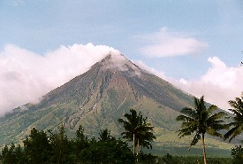 NASA satellite images taken on 12th December provide impressive visual evidence of the impact of ongoing ash and lava flows from Mayon Volcano in the Philippines. On November 30th, a torrential rainstorm turned the loose ash, which has been accumulating since July, into a series of mudslides. The mud reached the outskirts of Legazpi on the south and west volcano flanks and 1000 people are believed to have lost their lives. The images can be viewed via the link above. Click HERE for further information on NASA's Terra satellite. The disaster was originally reported by CNN. Image (Mayon Volcano) from http://www.arrakeen.ch/phil2/philippinesdec2000.html.
Monday, December 04, 2006
Floodline: Flooding in the UK
At this time when there are a number of severe flood warnings in the UK, it is useful to be reminded of the Floodline service provided by the Environment Agency (click link above for their web site). Floodline provides information on flood risk in your area (using an interactive map) and explains ways in which you can defend your property against flooding. The web site also gives current flood warnings and boasts an extensive library of publications relating to flooding and flood management. An excellent site for students of geomorphic hazards!
Thursday, October 12, 2006
99.9% of glaciers shrinking
Dr Georg Kaser (University of Innsbruck), President of the IUGG Commission for the Cryospheric Sciences and one of the lead authors of the IPCC 4th Assessment Report, and his team, have published the results of a global survey of glacier mass balance (Article: Kaser, G., Cogley, J. G., Dyurgerov, M. B., Meier, M. F. and Ohmura, A. 2006. Mass balance of glaciers and ice caps: Consensus estimates for 1961–2004, Geophysical Research Letters 33, L19501). The team concludes that there has been a sharp acceleration in the rate of glacier melting in the last five years and they attribute this directly to global warming. Worldwide glacier melting is likely to lead to substantial losses to water suplies for major areas of South America and Asia.
Thursday, October 05, 2006
Exploratory drilling triggers unstoppable mudflow....
A team of geologists from the University of Oslo has stated that efforts to stop the mud flowing 200m from a 2km deep exploratory borehole in East Java are "unlikely to succeed". The mud started gushing from the hole on May 29th and is continuing at a rate of 50,000m3 per day. Two villages have already been flooded and another four will probably have to be destroyed. There are suggestions that the resulting environmental devastation could reach the catastrophic proportions of the Exxon Valdez sunken oil tanker disaster in 1989, Alaska. The geological team have suggested four possible fundamental causes for the mudflow; gas-rich fluid breaching coral mounds on top of the limestone rock; gas produced from a magmatic reaction; a new mud volcano; or migration of hydrothermal fluids from nearby.
Monday, July 10, 2006
Eiger rockfall awaited
Geologists monitoring Mt. Eiger in the Swiss Alps have reported that a major fissure is opening up at the rate of 75cm per day, loosening a block of rock 2x10⁶ m3 in size. If the rockfall occurs (it is expected in the next few days), debris settling onto glaciers below could block streams and cause downstream flooding or affect water supplies, but there is no direct danger to Man or property. The report made to The Guardian blames global warming for this activity but no evidence for this is presented. It is much more likely to be part of the natural cycle of erosion and deposition occurring in the mountains.
Tuesday, April 04, 2006
Global glacier mass balance in decline
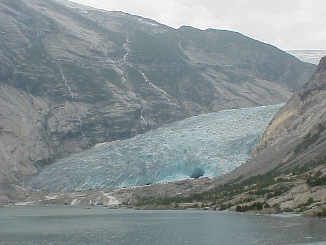 The World Glacier Monitoring Service (WGMS) based in Zurich collects and provides annual mass balance data for glaciers around the world. These data, reported by the WGMS at the recent European Geosciences Union meeting in Vienna, demonstrate a mean loss of 2.9% per decade from 1850 to 1970. This figure has increased to 8.2% for the period 1970 to 2000. Further information is available from the WGMS web site (from which mass balance data are available) and a recent BBC News report.
The image shows Nigardsbreen on the Jostedals ice cap in central Norway. This is one of the few glaciers which is currently advancing, against the gloabal trend....
Friday, March 31, 2006
Severe land degradation in Africa
A new report by The International Center for Soil Fertility and Agricultural Development (IFDC) presents findings of a programme of monitoring soil 'health' in Africa over the period 1980 to 2004. The IFDC concludes that in several countries the use of the land for agriculture is unsustainable because of nutrient depletion. This has arisen due to over-exploitation, use of marginal land and poor land management practices. The situation is exacerbated by the low usage of fertiliser in Africa which has one of the lowest rates of usage in the world.
Friday, February 17, 2006
Rain-induced landslide
Major mudslides have occurred in the Philippines, effectively submerging a village under thick mud. The death toll is still being assessed, but latest reports from the Philippine Red Cross, suggest that at least 200 people have lost their lives and as many as 2,000 are still missing. The landslides have occurred in Leyte Province, following torrential rain and flash flooding. However, while rainfall may have been the main CAUSE of the landslides, the TRIGGER may have been provided by a small earthquake according to Rene Solidum (Director of the Institute of Volcanology and Seismology in Manila). Other potential causes include logging (see report from New York Times).
Tuesday, January 17, 2006
Landslide in Dorset
On 14th January 2006 a landslide occurred near Charmouth in West Dorset and 17 people had to be rescued from rising tides due to the landslide debris. The landslide has destroyed more of the coastal path and new cracks have opened up in the fields above, indicating further activity is to come. The area is prone to landsliding because impermeable Jurassic clays and limestones underly permeable Cretaceous Greensand. Following prolonged rainfall, the accumulation of percolated water at the boundary between the two formations causes seepage, lubrication and a consequent loss of friction. The result is that the upper strata slide over the underlying strata.
For more information on the geology and landsliding along this stretch of coast, visit the Jurassic Coast web site
For more information on the geology and landsliding along this stretch of coast, visit the Jurassic Coast web site
Tuesday, December 06, 2005
World's tallest building triggers earthquake?
The world's tallest building, Taipei 101, situated in Tawain, is being blamed for the increased number and magnitude of earthquake tremors that have occurred beneath it. The building, situated on soft sedimentary rocks, is 508m tall and exerts 0.5Mpa on the ground. It has been argued that these stresses are transferred 10km down to the upper crust and have re-activated an ancient fault. Although the number and magnitude of earthquake tremors have increased since construction commenced, some argue that this could simple reflect short-term variability in the natural cycle of events. Others also argue that stresses cannot be transferred to such a depth below the Earth's surface. Furthermore, the total load applied to the ground by Taipei 101 is negligible compared to some stuructures such as dams. What do YOU think?
Tuesday, October 11, 2005
Natural disasters producing environmental refugees
According to the United Nations University, there are likely to be 50 million worldwide environmental refugees by 2010. The main sources of refugees are land degradation due to unsustainable land management; and flooding, exacerbated by global warming. The UNU have calculated that the number of refugees created by natural disasters exceeds that produced by war and conflict. The problems are likely to increase as environmental refugees join poor, squatter communities in urban areas.
Wednesday, August 31, 2005
Rapid glacier retreat in Peru
 The Peruvian tropics are host to many Andean glaciers. These are retreating rapidly due to global warming and it is anticiapted that all glaciers below 5500m will have melted in just TEN years time. The population of Peru mainly occupies a strip of arid desert lying between the oceans and the Andean mountains, and rely on glacial meltwater for their primary water supply. This meltwater supplies domestic, industrial and agricultural uses as well as providing a key source of hydroelectric power. The future for Peruvians looks gloomy.
Friday, August 12, 2005
Massive permafrost thaw in Siberia
The sub-Arctic region of western Siberia, an area spanning more than a million sq km, is undergoing permafrost thaw on a scale previously unprecedented. The delicate climatic threshold which maintains permafrost has been breached. As this essentially frozen peat bog thaws it will potentially release sufficient quantities of methane (a greenhouse gas considerably more damaging than CO2) to significantly raise global temperatures. Climatologists are said to be 'alarmed' at the finding by Sergei Kirpotin (Tomsk State University, western Siberia) and Judith Marquand (Oxford University). Further details can be found in The Guardian and New Scientist (11th August 2005).
Tuesday, August 09, 2005
Tsunami warning system for Indian Ocean countries
It has been agreed by countries flanking the Indian Ocean that a system of seabed sensors and sea-level buoys will be established to warn of potential tsunami threats. While installation of these various devices is expected to take until summer 2006 to be fully operational, the earliest sensors could be in place by December 2005.
Wednesday, August 03, 2005
Soil erosion produces biggest desert in Europe
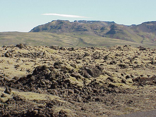 Centuries of unmanaged sheep grazing in Iceland has produced the biggest desert in Europe. Over 60% of the country is officially classified as desert, though the sand here is black and there is no shortage of water. Andres Arnalds, the Deputy Director of the Soil Conservation Service in Iceland, warns that desertification will happen elsewhere in the world where trees are being cleared and land is being over-used.
Subscribe to:
Posts (Atom)

