 The Tsho Rolpa glacial lake in the high Nepalese Himalayas, has been carefully monitored for a number of years. The lake is constrained by a moraine dam which is vulnerable to ground movements (from landslides, glacier falls and seismic activity) and from melting of ice blocks contained within it. The glacial outburst flood that could potentially result from a breach of the moraine dam would reach villages as far as 100km downvalley. Subsequent water shortages would have severe effects on the Ganges as well as Nepal. The glacier which feeds Tsho Rolpa has receded rapidly over the last 10 years - a function of global warming - and the lake grows in length by 100m each year. Controlled lake drainage via an artificial outlet channel ensures that water levels are gradually being reduced, but not at a sufficient rate to reduce pressure on the moraine. Nepal has 17 similar glacial lakes which have no control measures in place. Further information can be found at: http://tinyurl.com/ytkkpm. The image shows a small ice-marginal lake at Hoffelsjokull in Iceland.
Thursday, December 06, 2007
Tsho Rolpa outburst threatened
The Tsho Rolpa glacial lake in the high Nepalese Himalayas, has been carefully monitored for a number of years. The lake is constrained by a moraine dam which is vulnerable to ground movements (from landslides, glacier falls and seismic activity) and from melting of ice blocks contained within it. The glacial outburst flood that could potentially result from a breach of the moraine dam would reach villages as far as 100km downvalley. Subsequent water shortages would have severe effects on the Ganges as well as Nepal. The glacier which feeds Tsho Rolpa has receded rapidly over the last 10 years - a function of global warming - and the lake grows in length by 100m each year. Controlled lake drainage via an artificial outlet channel ensures that water levels are gradually being reduced, but not at a sufficient rate to reduce pressure on the moraine. Nepal has 17 similar glacial lakes which have no control measures in place. Further information can be found at: http://tinyurl.com/ytkkpm. The image shows a small ice-marginal lake at Hoffelsjokull in Iceland.


Friday, November 02, 2007
Flooding in Mexico
 Prolonged and heavy rainstorms over more than a week have caused seven rivers in the Mexican state of Tabasco to swell, flooding 70% of the land area of this Gulf coast state. It is thought that 100% of crops will be lost. Estimates vary as to the number of fatalities so far, but numbers are small. At the onset of the storms last week, 23 died in an oil rig collision. The state was similarly affected, though not as severly, by unprecendented rainfall in the summer of 1999 (further details at http://www.fas.usda.gov/pecad2/highlights/99-10/fsa101499.htm).
The image is copyright of BBC News.
Thursday, August 09, 2007
Calving glacier hazard
Holidaymakers aboard a cruise ship, sailing off Svalbard, were injured when calving ice from the Horn Glacier crashed onto the side and deck of the ship. It would appear that most injuries were caused due to the ship listing due to the ice collapse. It is unusual for the calving of glacier ice to result in direct risk to humans in this way but direct risk to tourists occurred at the Miage Glacier in the Italian Alps in 1996 (Tinti et al 1996).
Further reading:
TINTI S., MARAMAI A. and CERUTTI A. V. 1999. The Miage Glacier in the Valley of Aosta (Western Alps, Italy) and the extraordinary detachment which occurred on August 9, 1996. Physics and Chemistry of the Earth, Part A: Solid Earth and Geodesy, 24 (2), 157-161.
REYNOLDS, J. M. 1992. The identification and mitigation of glacier-related hazards: examples from the Cordillera Blanca, Peru. Chapter 13 In: G. J. H. McCall, D. J. C. Laming and S. C. Scott (eds). Geohazards: Natural and Man-made. Chapman and Hall, London, 143-157.
Further reading:
TINTI S., MARAMAI A. and CERUTTI A. V. 1999. The Miage Glacier in the Valley of Aosta (Western Alps, Italy) and the extraordinary detachment which occurred on August 9, 1996. Physics and Chemistry of the Earth, Part A: Solid Earth and Geodesy, 24 (2), 157-161.
REYNOLDS, J. M. 1992. The identification and mitigation of glacier-related hazards: examples from the Cordillera Blanca, Peru. Chapter 13 In: G. J. H. McCall, D. J. C. Laming and S. C. Scott (eds). Geohazards: Natural and Man-made. Chapman and Hall, London, 143-157.
Friday, July 20, 2007
More flash floods and landslides in the UK
Today has seen yet further incidents of flash flooding and associated chaos in the UK, including a landslide at the side of a motorway. BBC News report here: http://news.bbc.co.uk/1/hi/uk/6907316.stm BBC video clip here: http://tinyurl.com/2u33qq
Cataclysmic flood creates new island
A study by Sanjeev Gupta and Jenny Collier of Imperial College has revealed a deep, sub-marine trench through the English Channel which is believed to have been carved out by cataclysmic floods 400,000 years ago. The sub-marine scouring, identified on sonar images, is thought to have occurred due to overflow of a massive ice-dammed lake in the southern North Sea. It is estimated that the discharge was between 200,000 and 1 million cubic metres per second - this is at least four times as much as peak flow from the 1996 Icelandic jokulhlaup. Prior to this event Britain was connected to the European mainland via a land promontory.
Wednesday, June 20, 2007
Flash flooding in England
 Late yesterday evening (Tuesday 19th June) saw flash flooding in many areas of south west and central England. The photograph (Adam Heskins) shows what 15 minutes of rain did in Portishead. There are many reports of road damage and closures, helicopter rescues, airport closures, loss of power, and flooded homes. The Environment Agency still has 27 rivers and their tributaries on Flood Watch and the Met Office has continued to issue severe weather warnings, notably for Grampian region of Scotland which is expected to receive heavy rainfall throughout Wednesday 20th June. A BBC video can be found at: http://www.tiny.cc/flashflood
Tuesday, May 29, 2007
Columbian floods and landslides
Several villages in Columbia have been hit by flooding and landslides as a result of heavy rainfall. Floods have destroyed a number of homes. Flooding is exacerbated by sediment accumulation in rivers causing narrowing of the channel. Localised rain-induced mudslides have also left around 8 people, mainly children, dead.
Every year dozens of lives are lost as a direct result of the heavy annual rainfall. The poor, living in makeshift accommodation on steep hillslides, are most at risk.
Every year dozens of lives are lost as a direct result of the heavy annual rainfall. The poor, living in makeshift accommodation on steep hillslides, are most at risk.
Monday, April 09, 2007
Karst collapse in Borneo
A large sinkhole collapse in Sarawak, on the Malaysian island of Borneo, almost led to the loss of c.100 lives. A traditional longhouse, occupied by around 100 people, was quickly evacuated after a man, taking a late night trip to the toilet, raised the alarm when he felt the earth move beneath him and saw the end of the longhouse sinking into the ground.
For further information on the geology and karst landforms of the Sarawak region, visit http://www.oucc.org.uk/procs/proc11/borneo_karst.htm.
For further information on sinkholes, how they develop and why they collapse, visit http://www.dyetracing.com/karst/karst.html.
For further information on the geology and karst landforms of the Sarawak region, visit http://www.oucc.org.uk/procs/proc11/borneo_karst.htm.
For further information on sinkholes, how they develop and why they collapse, visit http://www.dyetracing.com/karst/karst.html.
Thursday, March 22, 2007
New Zealand lahar
 On 18th March 2007, a lahar (volcanic mud flow) spilled down Mount Ruapehu in New Zealand. After an eruption of the volcano in 1995, a 40m high wall of tephra had built up around the crater rim. In this latest event the wall was breached, allowing a mixture of acidic rock fragments, volcanic ash (tephra) and water to spill down the flanks of the mountain. Although there was reported to be no loss of life and no significant damage as a result of the lahar, the potential for extremely hazardous events still exists. This is demonstrated by a 1953 lahar from the same volacno which killed 151 people. The image is from NZPA/Stephen Barker/Associated Press.
For a video clip of the event go to the BBC link: Volcano spews rivers of mud
Friday, February 16, 2007
Tropical glacier disappearing

The Quelccaya ice cap is the largest ice sheet in the tropics and one if its outlet glacers, the Qori Kalis glacier, is fast shrinking due to global warming and the effects of El Nino. There are fears this Peruvian glacier could disappear within just five years as its current retreat rate is 60m yr-1. The report comes from work conducted by climate scientist, Professor Lonnie Thompson, from Ohio State Univeristy. The image is copied from the BBC web site (link above).
Tuesday, February 13, 2007
Shifting shores: Adaptation is the answer
 The National Trust have published a report 'Shifting Shores' on the effects of coastal flooding and erosion over the next century. The study, conducted by Halcrow, predicts that over 4,000 hectares of Trust land will be at risk of flooding and more than 600km will be subject to erosion. The causes of the predicted flooding and erosion include climate change (especially high tides and severe storms), the ongoing dynamic nature of coastal environments and isostatic rebound. The Trust pledges to take the long term view and adopt a plicy of adaptation rather than defence. This means adapting infrastructure and careful planning for recreation, heritage and wildlife. The full report can be downloaded at: http://www.nationaltrust.org.uk/main/w-shifting_shores.pdf
Tuesday, January 30, 2007
Glaciers shrinking faster

The BBC reports on new data available from the World Glacier Monitoring Service (http://www.wgms.ch/) which suggest that the rate of glacier shrinking due to global warming is now three times as fast as it was in the 1980's. The photo (from O. Gruber, H. Rentsch and M. Siebers from the Bavarian Academy of Sciences and Humanities) was taken in 1968 at Vernagtferner in Austria. Photos taken at the same location in 1912 and 2003 are shown in the BBC News item and demonstrate the huge shrinkage that has occurred over the last century. During 2005 alone, the glacier was reduced in thickness by more than 0.5m.
Friday, January 26, 2007
Indonesian mud volcano continues to erupt
Remember the unstoppable 'mud volcano' in East Java (see posting on 5th October 2006)? A new report into the disaster has been produced by a consortium of Durham, Cardiff and Aberdeen Universities and GeoPressure Technology Ltd, headed by Professor Richard Davies of Durham University’s Centre for Research into Earth Energy Systems (CeREES). They conclude that the flow is almost certainly the result of drilling. When drilling, boreholes are usually protected by steel casing to prevent collapse of the walls due to gas or fluid pressure. It appears that casing was not used during this exploratory drilling into an artesian limestone aquifer. The rock walls fractured, allowing a mud-water fluid mixture to rise to the surface. Poor drilling practice is cited as the most likely cause of the 'eruption'. The team have rejected antecedent earthquake activity as being a contributing factor. Having studied satellite imagery of the area, they also predict that ultimately, the central vent will collapse, forming a crater. There is further information and images in the BBC News report: http://news.bbc.co.uk/1/hi/world/asia-pacific/6293757.stm.
Thursday, December 14, 2006
Satellite images of Philippine mudslides
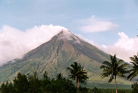 NASA satellite images taken on 12th December provide impressive visual evidence of the impact of ongoing ash and lava flows from Mayon Volcano in the Philippines. On November 30th, a torrential rainstorm turned the loose ash, which has been accumulating since July, into a series of mudslides. The mud reached the outskirts of Legazpi on the south and west volcano flanks and 1000 people are believed to have lost their lives. The images can be viewed via the link above. Click HERE for further information on NASA's Terra satellite. The disaster was originally reported by CNN. Image (Mayon Volcano) from http://www.arrakeen.ch/phil2/philippinesdec2000.html.
Monday, December 04, 2006
Floodline: Flooding in the UK
At this time when there are a number of severe flood warnings in the UK, it is useful to be reminded of the Floodline service provided by the Environment Agency (click link above for their web site). Floodline provides information on flood risk in your area (using an interactive map) and explains ways in which you can defend your property against flooding. The web site also gives current flood warnings and boasts an extensive library of publications relating to flooding and flood management. An excellent site for students of geomorphic hazards!
Thursday, October 12, 2006
99.9% of glaciers shrinking
Dr Georg Kaser (University of Innsbruck), President of the IUGG Commission for the Cryospheric Sciences and one of the lead authors of the IPCC 4th Assessment Report, and his team, have published the results of a global survey of glacier mass balance (Article: Kaser, G., Cogley, J. G., Dyurgerov, M. B., Meier, M. F. and Ohmura, A. 2006. Mass balance of glaciers and ice caps: Consensus estimates for 1961–2004, Geophysical Research Letters 33, L19501). The team concludes that there has been a sharp acceleration in the rate of glacier melting in the last five years and they attribute this directly to global warming. Worldwide glacier melting is likely to lead to substantial losses to water suplies for major areas of South America and Asia.
Thursday, October 05, 2006
Exploratory drilling triggers unstoppable mudflow....
A team of geologists from the University of Oslo has stated that efforts to stop the mud flowing 200m from a 2km deep exploratory borehole in East Java are "unlikely to succeed". The mud started gushing from the hole on May 29th and is continuing at a rate of 50,000m3 per day. Two villages have already been flooded and another four will probably have to be destroyed. There are suggestions that the resulting environmental devastation could reach the catastrophic proportions of the Exxon Valdez sunken oil tanker disaster in 1989, Alaska. The geological team have suggested four possible fundamental causes for the mudflow; gas-rich fluid breaching coral mounds on top of the limestone rock; gas produced from a magmatic reaction; a new mud volcano; or migration of hydrothermal fluids from nearby.
Monday, July 10, 2006
Eiger rockfall awaited
Geologists monitoring Mt. Eiger in the Swiss Alps have reported that a major fissure is opening up at the rate of 75cm per day, loosening a block of rock 2x10⁶ m3 in size. If the rockfall occurs (it is expected in the next few days), debris settling onto glaciers below could block streams and cause downstream flooding or affect water supplies, but there is no direct danger to Man or property. The report made to The Guardian blames global warming for this activity but no evidence for this is presented. It is much more likely to be part of the natural cycle of erosion and deposition occurring in the mountains.
Tuesday, April 04, 2006
Global glacier mass balance in decline
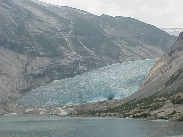 The World Glacier Monitoring Service (WGMS) based in Zurich collects and provides annual mass balance data for glaciers around the world. These data, reported by the WGMS at the recent European Geosciences Union meeting in Vienna, demonstrate a mean loss of 2.9% per decade from 1850 to 1970. This figure has increased to 8.2% for the period 1970 to 2000. Further information is available from the WGMS web site (from which mass balance data are available) and a recent BBC News report.
The image shows Nigardsbreen on the Jostedals ice cap in central Norway. This is one of the few glaciers which is currently advancing, against the gloabal trend....
Subscribe to:
Posts (Atom)

