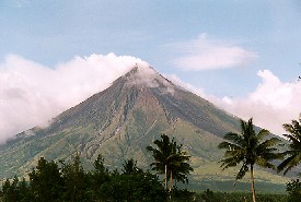
 NASA satellite images taken on 12th December provide impressive visual evidence of the impact of ongoing ash and lava flows from Mayon Volcano in the Philippines. On November 30th, a torrential rainstorm turned the loose ash, which has been accumulating since July, into a series of mudslides. The mud reached the outskirts of Legazpi on the south and west volcano flanks and 1000 people are believed to have lost their lives. The images can be viewed via the link above. Click HERE for further information on NASA's Terra satellite. The disaster was originally reported by CNN. Image (Mayon Volcano) from http://www.arrakeen.ch/phil2/philippinesdec2000.html.
Thursday, December 14, 2006
Satellite images of Philippine mudslides
NASA satellite images taken on 12th December provide impressive visual evidence of the impact of ongoing ash and lava flows from Mayon Volcano in the Philippines. On November 30th, a torrential rainstorm turned the loose ash, which has been accumulating since July, into a series of mudslides. The mud reached the outskirts of Legazpi on the south and west volcano flanks and 1000 people are believed to have lost their lives. The images can be viewed via the link above. Click HERE for further information on NASA's Terra satellite. The disaster was originally reported by CNN. Image (Mayon Volcano) from http://www.arrakeen.ch/phil2/philippinesdec2000.html.
Monday, December 04, 2006
Floodline: Flooding in the UK
At this time when there are a number of severe flood warnings in the UK, it is useful to be reminded of the Floodline service provided by the Environment Agency (click link above for their web site). Floodline provides information on flood risk in your area (using an interactive map) and explains ways in which you can defend your property against flooding. The web site also gives current flood warnings and boasts an extensive library of publications relating to flooding and flood management. An excellent site for students of geomorphic hazards!
Thursday, October 12, 2006
99.9% of glaciers shrinking
Dr Georg Kaser (University of Innsbruck), President of the IUGG Commission for the Cryospheric Sciences and one of the lead authors of the IPCC 4th Assessment Report, and his team, have published the results of a global survey of glacier mass balance (Article: Kaser, G., Cogley, J. G., Dyurgerov, M. B., Meier, M. F. and Ohmura, A. 2006. Mass balance of glaciers and ice caps: Consensus estimates for 1961–2004, Geophysical Research Letters 33, L19501). The team concludes that there has been a sharp acceleration in the rate of glacier melting in the last five years and they attribute this directly to global warming. Worldwide glacier melting is likely to lead to substantial losses to water suplies for major areas of South America and Asia.
Thursday, October 05, 2006
Exploratory drilling triggers unstoppable mudflow....
A team of geologists from the University of Oslo has stated that efforts to stop the mud flowing 200m from a 2km deep exploratory borehole in East Java are "unlikely to succeed". The mud started gushing from the hole on May 29th and is continuing at a rate of 50,000m3 per day. Two villages have already been flooded and another four will probably have to be destroyed. There are suggestions that the resulting environmental devastation could reach the catastrophic proportions of the Exxon Valdez sunken oil tanker disaster in 1989, Alaska. The geological team have suggested four possible fundamental causes for the mudflow; gas-rich fluid breaching coral mounds on top of the limestone rock; gas produced from a magmatic reaction; a new mud volcano; or migration of hydrothermal fluids from nearby.
Monday, July 10, 2006
Eiger rockfall awaited
Geologists monitoring Mt. Eiger in the Swiss Alps have reported that a major fissure is opening up at the rate of 75cm per day, loosening a block of rock 2x10⁶ m3 in size. If the rockfall occurs (it is expected in the next few days), debris settling onto glaciers below could block streams and cause downstream flooding or affect water supplies, but there is no direct danger to Man or property. The report made to The Guardian blames global warming for this activity but no evidence for this is presented. It is much more likely to be part of the natural cycle of erosion and deposition occurring in the mountains.
Tuesday, April 04, 2006
Global glacier mass balance in decline
 The World Glacier Monitoring Service (WGMS) based in Zurich collects and provides annual mass balance data for glaciers around the world. These data, reported by the WGMS at the recent European Geosciences Union meeting in Vienna, demonstrate a mean loss of 2.9% per decade from 1850 to 1970. This figure has increased to 8.2% for the period 1970 to 2000. Further information is available from the WGMS web site (from which mass balance data are available) and a recent BBC News report.
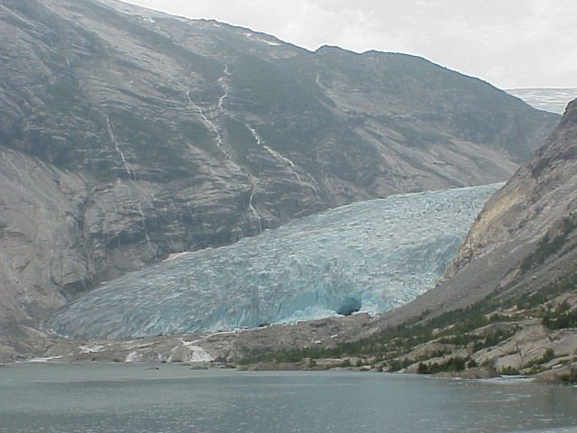
The image shows Nigardsbreen on the Jostedals ice cap in central Norway. This is one of the few glaciers which is currently advancing, against the gloabal trend....
Friday, March 31, 2006
Severe land degradation in Africa
A new report by The International Center for Soil Fertility and Agricultural Development (IFDC) presents findings of a programme of monitoring soil 'health' in Africa over the period 1980 to 2004. The IFDC concludes that in several countries the use of the land for agriculture is unsustainable because of nutrient depletion. This has arisen due to over-exploitation, use of marginal land and poor land management practices. The situation is exacerbated by the low usage of fertiliser in Africa which has one of the lowest rates of usage in the world.
Friday, February 17, 2006
Rain-induced landslide
Major mudslides have occurred in the Philippines, effectively submerging a village under thick mud. The death toll is still being assessed, but latest reports from the Philippine Red Cross, suggest that at least 200 people have lost their lives and as many as 2,000 are still missing. The landslides have occurred in Leyte Province, following torrential rain and flash flooding. However, while rainfall may have been the main CAUSE of the landslides, the TRIGGER may have been provided by a small earthquake according to Rene Solidum (Director of the Institute of Volcanology and Seismology in Manila). Other potential causes include logging (see report from New York Times).
Tuesday, January 17, 2006
Landslide in Dorset
On 14th January 2006 a landslide occurred near Charmouth in West Dorset and 17 people had to be rescued from rising tides due to the landslide debris. The landslide has destroyed more of the coastal path and new cracks have opened up in the fields above, indicating further activity is to come. The area is prone to landsliding because impermeable Jurassic clays and limestones underly permeable Cretaceous Greensand. Following prolonged rainfall, the accumulation of percolated water at the boundary between the two formations causes seepage, lubrication and a consequent loss of friction. The result is that the upper strata slide over the underlying strata.
For more information on the geology and landsliding along this stretch of coast, visit the Jurassic Coast web site
For more information on the geology and landsliding along this stretch of coast, visit the Jurassic Coast web site
Subscribe to:
Posts (Atom)