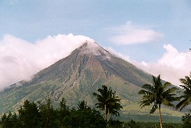
 NASA satellite images taken on 12th December provide impressive visual evidence of the impact of ongoing ash and lava flows from Mayon Volcano in the Philippines. On November 30th, a torrential rainstorm turned the loose ash, which has been accumulating since July, into a series of mudslides. The mud reached the outskirts of Legazpi on the south and west volcano flanks and 1000 people are believed to have lost their lives. The images can be viewed via the link above. Click HERE for further information on NASA's Terra satellite. The disaster was originally reported by CNN. Image (Mayon Volcano) from http://www.arrakeen.ch/phil2/philippinesdec2000.html.
Thursday, December 14, 2006
Satellite images of Philippine mudslides
NASA satellite images taken on 12th December provide impressive visual evidence of the impact of ongoing ash and lava flows from Mayon Volcano in the Philippines. On November 30th, a torrential rainstorm turned the loose ash, which has been accumulating since July, into a series of mudslides. The mud reached the outskirts of Legazpi on the south and west volcano flanks and 1000 people are believed to have lost their lives. The images can be viewed via the link above. Click HERE for further information on NASA's Terra satellite. The disaster was originally reported by CNN. Image (Mayon Volcano) from http://www.arrakeen.ch/phil2/philippinesdec2000.html.
Monday, December 04, 2006
Floodline: Flooding in the UK
At this time when there are a number of severe flood warnings in the UK, it is useful to be reminded of the Floodline service provided by the Environment Agency (click link above for their web site). Floodline provides information on flood risk in your area (using an interactive map) and explains ways in which you can defend your property against flooding. The web site also gives current flood warnings and boasts an extensive library of publications relating to flooding and flood management. An excellent site for students of geomorphic hazards!
Subscribe to:
Posts (Atom)